
In 1906, Americans saw the destruction of the San Francisco earthquake in a way no one ever had before, from 2,000 feet in the air.
There were no airplanes. No drones. No satellites.
Just a 49-pound camera lifted by a train of kites over a burned-out city.
George R. Lawrence’s aerial photograph documented a disaster and changed how the world understood catastrophe.
Even if you’ve never seen it before, one photograph of ruined San Francisco after the 1906 earthquake has quietly become the iconic view of the disaster: a long, sweeping panorama of the city, its downtown flattened and smoldering.
Lawrence summed up his business with a line that sounds like hype until you see what he did with it:
“The hitherto impossible in photography is our specialty.”
He was determined to achieve the impossible. The San Francisco panorama is the best proof he meant it.
“Flashlight” Lawrence: Making the Impossible a Business Model
George Raymond Lawrence was born in 1868 in Ottawa, Illinois, and moved to Chicago as a young man. By the early 1890s he had opened his own studio on Chicago’s South Side.
He didn’t stay a conventional portrait photographer for long. In the mid‑1890s he built a reputation as “Flashlight Lawrence” for using blazing magnesium flares to light enormous interior scenes—banquets, factories, political gatherings—decades before safe flashbulbs existed. The work literally blew up in his face: explosions singed off his hair and damaged his hearing.
Instead of backing down, he engineered his way out of the problem, devising systems to contain the smoke and flame so he could keep taking oversized, technically risky jobs. That habit—solve the technical problem, then sell the result—runs straight through to his aerial work.
Building the World’s Largest Camera
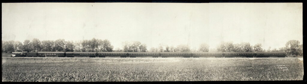
In 1900, Chicago & Alton Railway asked whether Lawrence could produce an enormous photograph of its new luxury train, the Alton Limited, for display at the Paris Exposition. They wanted an eight‑foot‑long image of the entire train, in one shot.
Lawrence first suggested photographing the train in sections and compositing the images. The railroad rejected the idea; they wanted continuous, “truthful” perspective. His answer was audacious: build a camera big enough to expose a single glass plate 8 feet by 4½ feet.
The “Mammoth Camera” that resulted:
- weighed about 1,400 pounds with plate holder
- used twenty‑foot bellows
- required a team of about fifteen men to move and operate
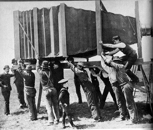
The final contact print of The Largest Photograph in the World of the Handsomest Train in the World impressed judges in Paris and earned Lawrence a grand prize for photographic excellence.
That project did two things for him: It proved he could deliver what skeptics called impossible and it trained him to think in terms of huge single‑negative images—an outlook that would pay off over San Francisco.
From Balloons to Kites: Inventing the “Captive Airship”
By the turn of the century, Lawrence was chasing a new problem: how to get a camera high enough above a city to create truly sweeping panoramas.
He started with gas balloons. To keep the view unobstructed, he replaced the normal basket with an open platform so he and the camera could hang below the envelope. It worked—until June 1901. That’s when a balloon broke loose while he was photographing the Chicago Union Stock Yards, drifted over Lake Michigan, and the platform failed. He fell more than 200 feet, surviving only because he crashed through a mesh of telegraph wires.
After that, he decided that getting himself off the ground was the wrong design choice.
Adopting a Proven Solution
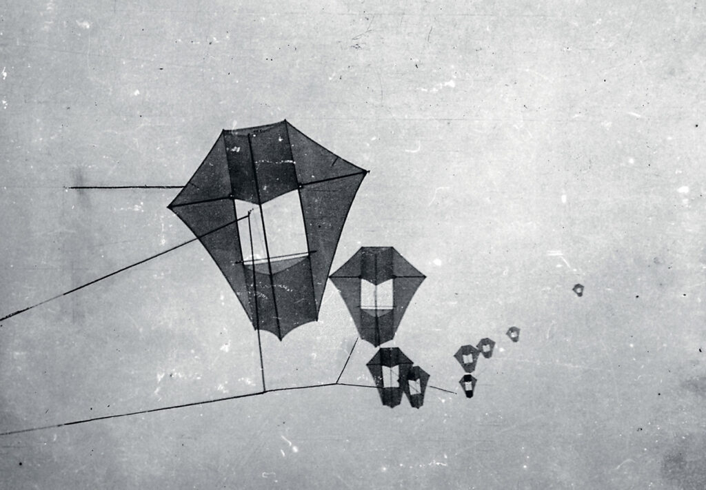
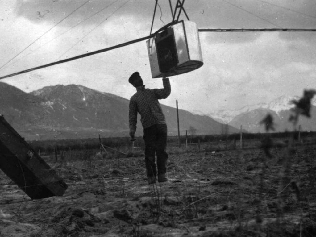
Lawrence’s solution was to keep his feet on the deck and send only the camera aloft. Multiple box‑kites (Conyne kites) were strung in a train. The camera was attached to a bridle on the kite line, and stabilized it with a small, insect‑like framework and tail assembly. He called this rig his “Captive Airship.”
He wasn’t the first to hang a camera under a kite. French experimenter Arthur Batut had done that in the 1880s. But Lawrence turned the idea into a heavy-lift system capable of hauling a panoramic camera thousands of feet into the air.
Key features of the Captive Airship system:
- Kite train: 9–17 kites flying on a single line, generating enough lift to hoist a roughly 50‑pound panoramic camera hundreds or even thousands of feet up.
- Panoramic camera: Built to expose long, curved negatives on flexible celluloid film, around 18 x 48 inches.
- Remote control: Lawrence used an insulated “messenger” line to send an electrical pulse that tripped the shutter, along with a simple system to adjust tilt and exposure.
By 1905 he was demonstrating this rig to the U.S. Navy as a potential reconnaissance platform, flying it over a battleship in New York harbor. The Navy was intrigued but didn’t buy in.
History did.
Documenting a Disaster with Aerial Photography
At 5:12 a.m. on April 18, 1906, the great earthquake struck San Francisco. Fires raged for three days. Roughly two‑thirds of the city was destroyed.
Newspapers everywhere carried the story. Lawrence saw something else: a chance to apply his Captive Airship to a subject the world desperately wanted to see from above.
Within weeks he and his crew shipped their kites, cameras, and gear to California. Several accounts describe them working from a small boat in the bay, flying the kite train out over the waterfront so the camera could look back toward the city.
On May 28, 1906, they got the shot that made him famous.
“San Francisco in Ruins”: How the Panorama Worked
The image we usually call San Francisco in Ruins (Lawrence used several long captions) is a roughly 160‑degree panorama taken from about 2,000 feet above the bay.
Technically, it’s remarkable even by today’s standards:
- Altitude: The camera hung about 2,000 feet above the water, stabilized by the kite train and the airship frame.
- Negative: Exposed on a single 17 x 48 inch strip of celluloid film, curved inside the camera to match the rotation of the lens.
- Field of view: About 160 degrees, sweeping from the Ferry Building and waterfront up Market Street and across the shattered grid of the downtown core.
- Prints: Contact prints around 18 x 48 inches, sold for $125 apiece—a premium price in 1906.
From a distance, the photograph reads as a single, coherent view of the ruined city, with sunlight breaking through the clouds over the Golden Gate. Move closer to the original photo and you can pick out individual signs on the waterfront, chords of rail line, and tiny figures picking through rubble. That mix of sweeping context and forensic detail is what later aerial survey and reconnaissance photography would chase using airplanes and satellites.
Lawrence didn’t stop at one frame. He and his crew produced multiple panoramas over different parts of the city—Nob Hill, for example—often from slightly different heights and positions, all using the same kite‑camera system.
Fame, Skepticism, and a Very Profitable Negative
The San Francisco panorama went around the world. Newspapers and magazines reproduced it; prints were marketed aggressively as souvenirs and documentary records. Institutions like the Library of Congress acquired copies that are still consulted today for urban and seismic history.
Lawrence reportedly earned more than $15,000 from that one negative—a fortune at the time—by selling prints at $125 each.
The clarity that made the image valuable also made some viewers suspicious. Just as critics had doubted his giant train portrait, people claimed the San Francisco panorama must be a composite fake. In Paris, the earlier train controversy had been settled when the French consul personally inspected the Mammoth Camera and its huge glass plate.
By 1906, Lawrence’s technical reputation—and the sheer physicality of his cameras and kites—helped quiet doubts. The “impossible” view really did exist on a single piece of film.
Beyond San Francisco: Aerial Panoramas Before Airplanes
San Francisco wasn’t a one‑off. Lawrence used his Captive Airship system to photograph racetracks, ballparks, military installations, and Midwestern cities from similar altitudes, selling panoramic views to railroads, municipalities, and promoters.
Within a few years, though, technology began to pass him. Airplanes offered more flexible platforms. By the 1910s he had largely shifted his inventive energy into aircraft design and aviation patents, leaving aerial photography to evolve into a new phase.
Still, that brief window—roughly 1901 to 1908—when one determined photographer could dominate aerial urban imagery with kites and giant panoramic cameras is unique.
Why Lawrence Still Matters in the Age of Orthophotos and Drones
Look at San Francisco in Ruins next to any modern vertical frame from the HistoricAerials archive. The technologies are wildly different: celluloid versus digital sensors, kite trains versus fixed‑wing aircraft and satellites. But the underlying questions are the same:
- How do you capture a landscape at a scale the human eye can’t grasp from the ground?
- How do you preserve enough detail that the image is still useful decades later?
- How do you earn trust in a photograph that no ordinary person could witness directly?
Lawrence wrestled with all of that using wooden cameras, magnesium flash, balloons, and kites. His Mammoth Camera anticipated single‑frame, high‑resolution mapping; his Captive Airship foreshadowed remote, stabilized aerial platforms.
When you scroll across a stitched aerial mosaic today, or compare change over time in an online viewer, you’re working in a visual tradition he helped define. The 1906 panorama of San Francisco isn’t just a spectacular image of destruction. It’s an early, successful proof of concept for the kind of large‑scale, detail‑rich aerial imagery that underpins everything from historical research to environmental consulting today.