Historic aerial imagery plays a critical role in archaeology by preserving time depth—revealing how landscapes changed long before modern development erased surface evidence.
A farm field in midsummer looks like a blank page—flat, orderly, and (to the untrained eye) unremarkable. But the air has a way of turning ordinary ground into a palimpsest. A faint curve in a crop line. A rectangle that shouldn’t be there. A darker band where the soil holds moisture just a little longer than the rest. The landscape doesn’t announce its past; it leaks it—subtly, inconsistently, and often only under the right conditions.
Archaeologists already know this. The challenge isn’t awareness. The challenge is operationalizing it: turning aerial trace-reading into a repeatable workflow that helps you decide where to spend limited time, money, and attention—especially when modern development has erased the surface context you’d normally rely on.
That’s where historic aerial imagery earns its keep. Not as a novelty, and not as a replacement for fieldwork or modern remote sensing—but as a time machine for landscape context. And when you pair it intelligently with LiDAR, it becomes more than “old photos.” It becomes a practical way to reduce uncertainty, strengthen interpretation, and document what no longer exists.
The Pain Point Archaeologists Don’t Need Explained (But Do Need Solved)
If you work in archaeology—academic, CRM, heritage management, or research support—you’re probably familiar with the modern contradiction: the more we care about preservation, the faster landscapes change.
- Development deadlines arrive faster than field seasons.
- Permitting and reporting demands expand while budgets don’t.
- Many of the most archaeologically rich areas are precisely the ones being disturbed first.
- And even when a site survives, the surrounding context—drainage, vegetation, field boundaries, access routes—often doesn’t.
In that environment, the biggest enemy isn’t ignorance. It’s triage.
Historic aerials help because they compress time. They let you reconstruct what a place looked like before the bulldozers, before the tree canopy matured, before the river was straightened, before the subdivision turned a ridge into a cul-de-sac. That’s not nostalgia. That’s data.
Aerial Archaeology Isn’t “Basics.” It’s a Discipline of Conditions.
Aerial interpretation is sometimes treated like a handful of textbook concepts—crop marks, soil marks, shadow marks—and then politely set aside as something everyone already knows. But in practice, aerial archaeology is less about memorizing categories and more about managing variables.
The same feature can be:
- invisible in one year
- obvious in another
- misleading in a third
Why? Because aerial traces are conditional signals. They appear (or don’t) based on sun angle, moisture, crop type, plow regime, vegetation stress, and surface disturbance. That’s exactly why time depth matters so much.
Instead of asking, “Can I see archaeology in this photo?” a better operational question is:
“Across multiple years and conditions, do I see repeatable anomalies that behave like archaeology?”
That’s the difference between a neat example and a defensible lead.
The Aerial Toolkit: Managing Variables, Not Just Marks
Every archaeologist knows the “Big Three” of aerial prospection. But in a professional workflow, the goal isn’t just to spot them—it’s to understand the conditions that created them.
1. Shadow Marks: The Microtopography Filter
- The Signal: Low-angle light (early morning/late evening) catching relief too subtle to see at noon.
- The Workflow Reality: In modern CRM, we often only have one “modern” aerial. Historic stacks allow you to check multiple sun angles across different decades.
- The Payoff: Distinguishing a genuine cultural feature (like a degraded mound or linear bank) from modern “agricultural noise” like old fence lines or tractor ruts.
2. Soil Marks: The Window of Exposure
- The Signal: Contrasts in soil color/texture—foundation rubble, organic-rich pits, or clay-heavy ditch fills.
- The Workflow Reality: These are the most fleeting traces. A field is only “bare” for a few days a year.
- The Payoff: Historic imagery captures the landscape in “transition”—moments of post-plowing exposure or pre-pavement grading that will never be visible again.
3. Crop Marks: The Phenology Variable
The Payoff: Proving persistence. A single crop mark is a lead; a recurring crop mark across three decades is a defensible site boundary.
The Signal: Differential growth based on subsurface moisture—stunted over walls, lush over ditches.
The Workflow Reality: This is where “Time Depth” acts as your control group. If an anomaly appears in 1954 (a drought year) but vanishes in 1960 (a wet year), you’ve just confirmed it’s a moisture-sensitive feature.
The Missing Dimension: Time Depth as Method
A single aerial image can be inspirational. A stack of aerials can be methodological.
With multi-decade coverage, you can:
- Track land-use change (field to suburb; pasture to orchard; wetland drained; channel altered)
- Recover erased features (old road alignments, demolished structures, vanished field systems)
- Locate former exposures (temporary cuts, borrow pits, grading episodes)
- Identify disturbance history (when was the area leveled, terraced, or heavily reworked?)
For archaeologists, this matters because a “site” is rarely just a dot. It’s a relationship between features and their setting. Historic aerials help you reconstruct that setting—sometimes the only way to understand why a place was chosen, how it functioned, and what later destroyed or obscured it.
For historians and other researchers, that time depth can provide the connective tissue between documentary sources and the ground itself: the “where” that makes the “what” interpretable.
Where LiDAR Fits: Not a Replacement—A Force Multiplier
LiDAR has earned its reputation. It can penetrate vegetation, expose microrelief, and model terrain with precision that earlier generations of aerial archaeologists could only dream about. But the healthiest way to integrate LiDAR into an archaeology-from-above article is to treat it as a layer in a workflow, not an isolated miracle.
Here’s the honest reality:
- LiDAR coverage isn’t universal.
- Processing pipelines can be time-consuming.
- Interpretation still requires context.
Historic aerials complement LiDAR in three key ways.
1) Historic aerials explain what LiDAR can’t: past surfaces
LiDAR gives you today’s ground shape (or a model of it). It doesn’t automatically tell you what was bulldozed, infilled, graded, or landscaped before the scan.
Historic aerials can show:
- when a terrace was cut
- when a mound was leveled
- when a drainage ditch appeared
- when a roadbed shifted
That matters when you’re trying to decide whether a LiDAR feature is ancient, modern, or mixed.
2) LiDAR validates and refines aerial leads
When aerial imagery suggests enclosures, banks, hollow ways, or subtle earthworks, LiDAR can:
- confirm microtopographic expression
- sharpen boundaries
- reveal connecting features hidden in canopy
- expose broader systems (causeways, field boundaries, settlement grids)
Aerial interpretation often gives you the “shape.” LiDAR can give you the “relief.” Together they give you a more defensible story.
3) Together, they reduce false positives and wasted effort
Every archaeologist has chased an anomaly that turned out to be agricultural noise, irrigation patterns, or soil variability. The fastest way to burn budget is to treat a single dataset as gospel.
A layered approach is more efficient:
- Use historic aerials to identify persistent, structured anomalies across time.
- Use LiDAR to test whether the anomaly corresponds to terrain expression.
- Use ground truth strategically where the combined evidence is strongest.
That’s not just better science. It’s better triage.
A Practical Workflow Archaeologists Can Actually Use
If you want a repeatable approach (without turning your desk into a methodological crime scene), here’s a simple sequence:
- Start with the research question. Prospection? Context reconstruction? Damage assessment? Publication-quality interpretation?
- Build a time stack. Pull multiple years—prior to major development and across different seasons when possible.
- Scan for repeatable anomalies. Focus on geometry, persistence, and landscape logic.
- Annotate and compare. Track what appears, disappears, and shifts across years.
- Bring in LiDAR (if available). Use it to validate relief, connections, and broader system structure.
- Document disturbance history. Identify grading, drainage, plowing intensification, and construction phases.
- Prioritize ground checks. Let the combined evidence guide where boots-on-ground will be most efficient.
This is where historic aerial imagery quietly shines: it makes your interpretation less dependent on luck and more dependent on pattern.
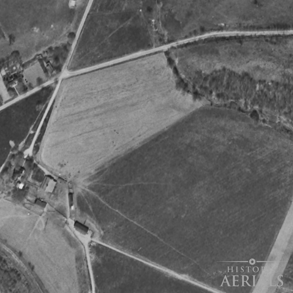
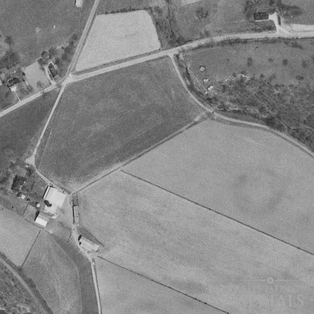
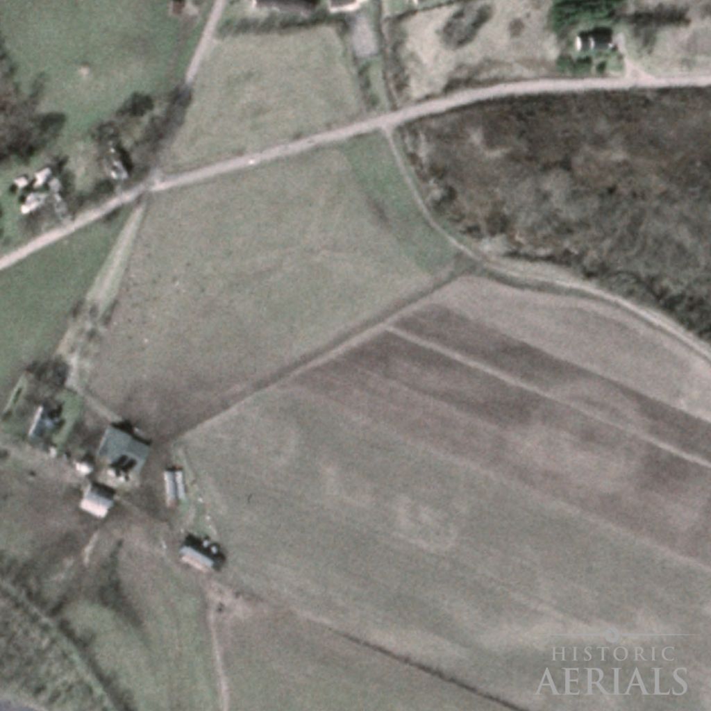
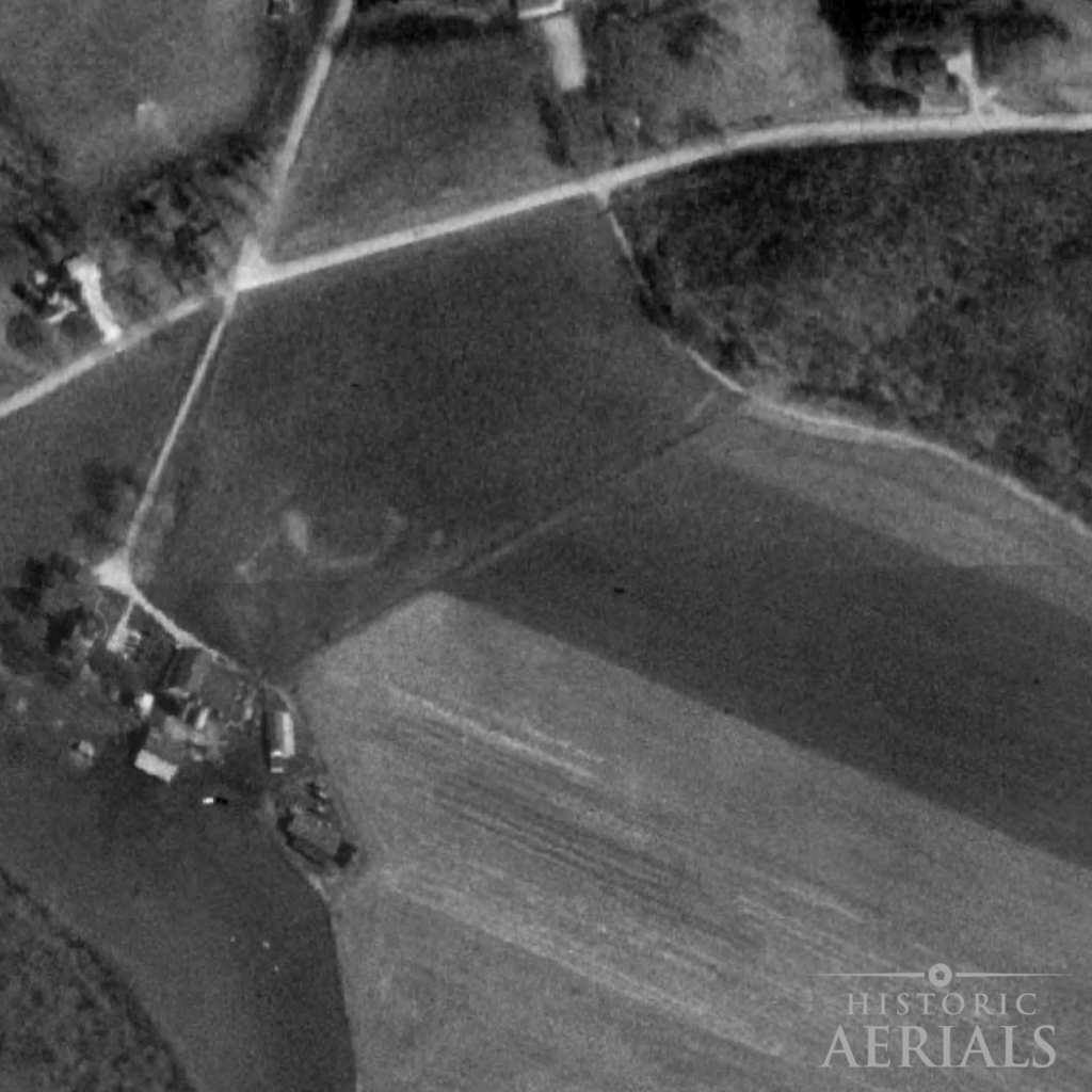
Theory and workflow are essential, but the true value of time depth is clearest when a site is on the brink of disappearing. The Junction Earthworks in Ohio offer exactly that kind of test case.
Case Study: The Junction Earthworks (Ross County, Ohio)
The aerial record did not solve the site’s geometry, but it ensured that the landscape never fully went silent.
When time depth mattered more than certainty
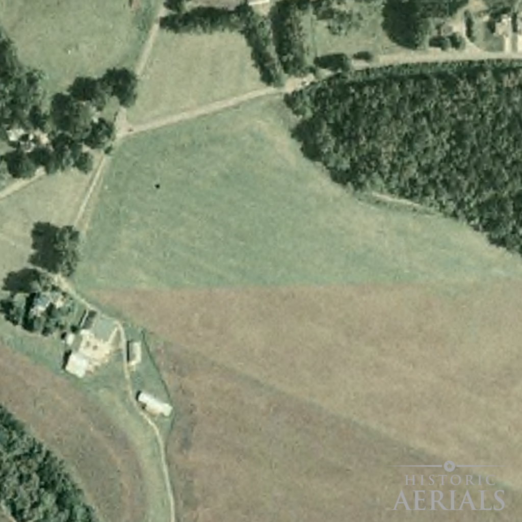
In 2014, the Junction Earthworks—a little‑known Hopewell‑era ceremonial site near Chillicothe—came within weeks of being sold at auction and redeveloped as a housing subdivision. To most observers, the landscape looked unremarkable: a working farm field with no visible mounds, no obvious embankments, and no surface clues that it once held one of the Scioto Valley’s more unusual earthwork complexes.
That apparent absence was not evidence of absence. It was evidence of loss.
The Vanishing Surface
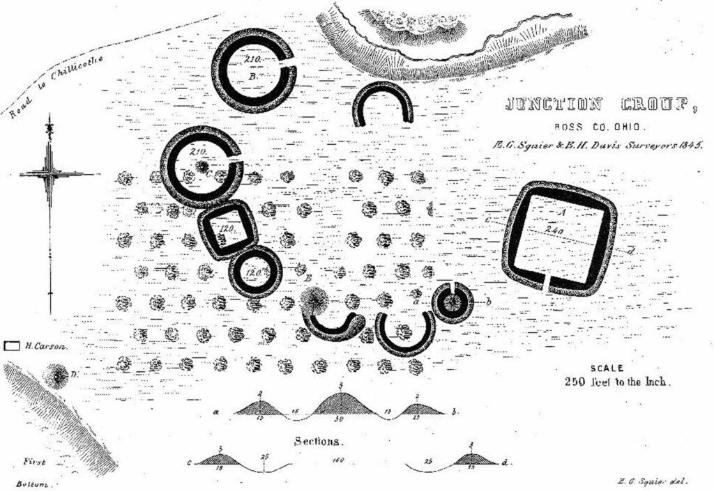
The site had been documented as early as the 1840s by Ephraim Squier and Edwin Davis, who recorded visible earthworks—some standing several feet high—in their landmark Ancient Monuments of the Mississippi Valley (1848). Over the next century and a half, continuous plowing gradually erased those features from the surface. By the late twentieth century, ground‑based observation alone could no longer recover the site’s form.
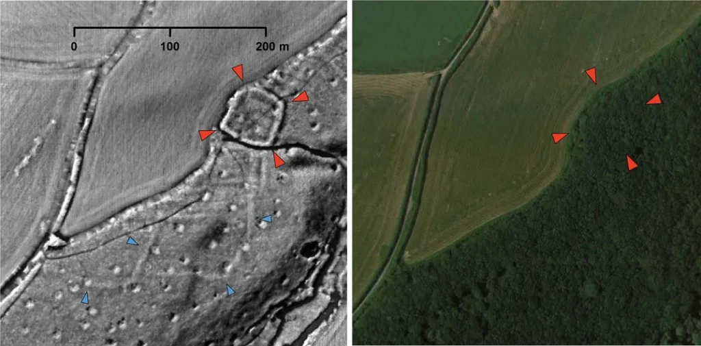
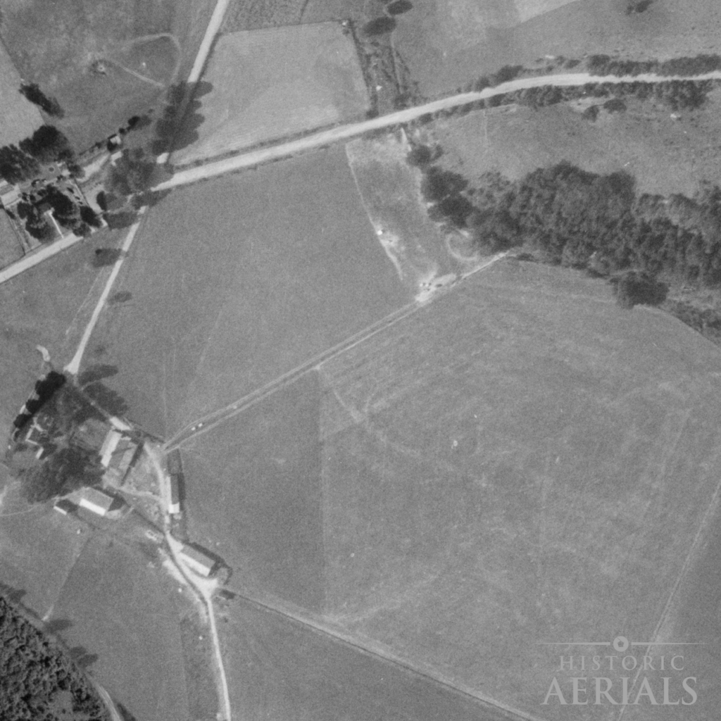
Historic aerial imagery complicates that story. Beginning with mid‑twentieth‑century photographs, faint and inconsistent crop and soil variations appear within the cultivated fields. In many years, nothing meaningful is visible at all. In others, partial arcs or tonal shifts briefly emerge and then vanish again. Taken individually, any one of these images would be easy—and responsible—to dismiss as agricultural noise.
The value of the aerial record lies not in any single photograph, but in comparison across time. When images from different decades are viewed together, certain anomalies recur in roughly the same locations, while others do not. Phenology plays a decisive role here: rainfall timing, crop type, and growth stage determine whether subsurface features express themselves at all. A June image from one year may hint at archaeology that is completely invisible in June the next. Historic aerial stacks preserve those fleeting moments.
One such faint circular anomaly appears in an early aerial photograph near the area later confirmed as part of the site’s distinctive quatrefoil configuration. At the time, interpreting that trace as a simple circular enclosure would have been entirely reasonable—and consistent with how the site had been understood for more than a century. Nothing in the aerial imagery alone demands a more complex interpretation.
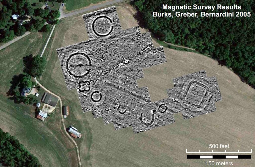
The Breakthrough
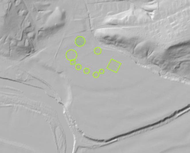
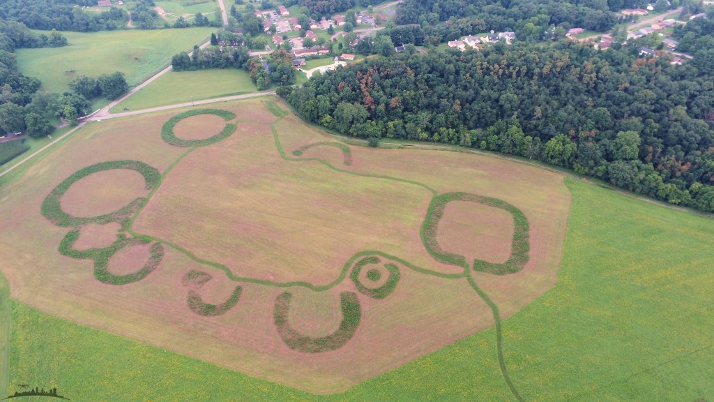
That ambiguity was resolved in 2005–2006, when archaeologist Jarrod Burks (Ohio Valley Archaeology, Inc.) conducted a magnetic survey of the farmland. Magnetometry revealed that the earthworks were not simply circular, but formed a rare and intricate quatrefoil (four‑lobed) plan, preserved below the plow zone despite generations of agricultural disturbance. The geophysical data did not contradict the aerial record; it explained why that record had always been incomplete.
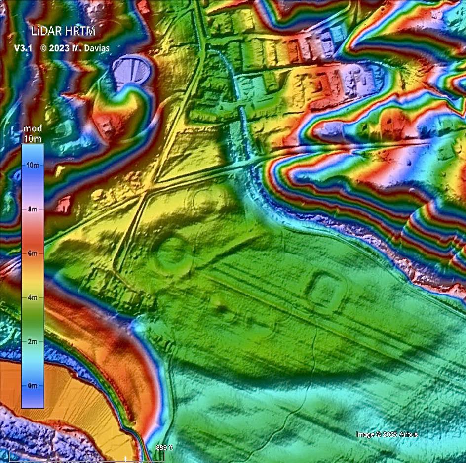
More recently, LiDAR‑derived terrain models have shown that portions of the Junction Earthworks still retain measurable micro‑relief. This underscores how much of the site survived beneath the plow—and also clarifies LiDAR’s role in the workflow. LiDAR reveals present‑day relief, not past surface expression. It cannot show how much topography was already lost before modern scanning, or how the site appeared at earlier stages of degradation. That temporal context comes only from historic imagery.
The aerial record did not solve the site’s geometry, but it ensured that the landscape never fully went silent. That continuity mattered in 2014, when the property was slated for auction and potential development. A coalition led by the Arc of Appalachia raised approximately $375,000 in just two weeks to purchase and protect the site, preventing its conversion into a housing subdivision. Without the layered record—early surveys, aerial imagery, and modern geophysics—the site’s significance would have been far easier to overlook.
The “Junction” Lesson
As a case study, Junction is a reminder that aerial archaeology is not about finding perfect images. It is about resisting overinterpretation, recognizing persistence amid noise, and using time depth as a methodological tool. Sometimes the most important contribution an aerial photograph makes is not what it reveals clearly, but what it refuses to let disappear.
The Junction Earthworks survived because a layered record of data made it impossible to ignore. In an era of rapid development, we cannot afford to wait for “perfect” conditions or a single miracle technology to tell us where the past remains. We have to be proactive.
Why This Matters Right Now
Archaeology is increasingly asked to do two things at once: discover and defend—to locate what matters and to justify why it matters in a world that’s busy paving it.
Historic aerial imagery helps with both.
It helps you discover by revealing traces that never make it into modern basemaps. It helps you defend by documenting what was present before disturbance, and by providing visual context that makes interpretation legible to non-specialists—planners, agencies, reviewers, clients, and the public.
And when you pair historic aerials with LiDAR, you’re not choosing between old and new. You’re building a workflow that treats the landscape like the layered record it is.
The past isn’t always buried deep. Sometimes it’s sitting in plain sight—waiting for the right light, the right year, and the right set of eyes to connect the dots.
Put Time Depth to Work in Archaeological Research
If you’re working on a survey area, a research project, a mitigation plan, or a landscape history—and you need to understand what a place looked like before modern change erased the evidence—historic aerial imagery provides something no single dataset can: context over time.
Rather than repeating the same task with different tools, historic aerials support distinct, complementary decisions across a project’s life cycle:
- Assess archaeological potential: Compare decades of imagery to identify recurring crop, soil, or shadow anomalies that warrant closer attention.
- Document disturbance history: Establish when grading, plowing, channelization, or construction altered a landscape—critical for compliance, reporting, and defensibility.
- Reconstruct lost context: Recover former field systems, roads, waterways, and land-use patterns that shaped how a site functioned.
- Integrate with LiDAR and geophysics: Use time depth to guide where higher-resolution methods are most likely to be productive.
Historic aerials don’t replace other tools—they help you decide when and where to use them.
Join thousands of professionals who use HistoricAerials.com to see through the modern surface and uncover the patterns that matter.