When the balloon first rose over Africa, it was not over a battlefield, but as a spectacle. In 1798, during Napoleon Bonaparte’s Egyptian campaign, a hydrogen balloon was brought to Cairo alongside soldiers, scientists, and surveyors. Napoleon imagined conquest guided as much by knowledge as by force. The experiment ended ignominiously—the balloon crashed shortly after launch, alarming local spectators more than it informed French commanders. Yet even in failure, it introduced a provocative idea: that elevation itself could be a weapon.
In this installment of Balloons of War, we follow military ballooning as it moves across the African continent during the late nineteenth century. Colonial warfare—fought over vast, unfamiliar terrain—became an unintentional proving ground for aerial reconnaissance. Britain and Italy, in particular, turned to balloons not for spectacle, but for information.
British Balloons in the Desert
By the 1880s, Britain was cautiously transitioning military ballooning from experiment to practice. Building on the institutional groundwork laid by the Royal Engineers, British forces deployed balloons during the Bechuanaland Expedition (1884–85) and the Sudan campaign (1885). These early operations were constrained by harsh climates, limited infrastructure, and the logistical burden of hydrogen generation in the field.
Even so, balloon observers provided commanders with something previously unattainable: wide-area situational awareness. From a few hundred feet above the ground, they could trace river courses, identify encampments, and monitor troop movements across open desert and savannah. In campaigns where cavalry patrols struggled with distance and visibility, the balloon offered a commanding vantage point.
What observers saw, however, did not translate cleanly into immediate understanding. From above, the battlefield often appeared fragmented and ambiguous—lines dissolved, scale distorted, and familiar landmarks vanished. Interpreting the view required experience, context, and careful cross-referencing with ground reports. This tension between visibility and legibility would become a defining challenge of aerial reconnaissance, one that later aerial photographers and interpreters would inherit.
Italy’s Aerial Experiment in East Africa
Italy’s late nineteenth-century imperial ambitions extended balloon reconnaissance into East Africa during the First Italo–Ethiopian War (1895–96). Italian forces deployed a hydrogen-filled captive balloon inflated using compressed gas cylinders—a technological step forward from earlier field-generated hydrogen.
The balloon was intended to spot Ethiopian troop concentrations and guide Italian movements across unfamiliar highland terrain. In practice, its impact was minimal. Italy suffered a decisive defeat at the Battle of Adwa, and the balloon remains a historical footnote rather than a decisive factor. Nevertheless, it marked one of the earliest uses of aerial reconnaissance in sub-Saharan Africa, underscoring how rapidly military ballooning was spreading beyond Europe.
As with British operations, the promise of elevation collided with the limits of interpretation. Without standardized photographic methods or established visual conventions, aerial views were often suggestive rather than definitive—useful for orientation, but rarely decisive on their own.
The Second Boer War: Balloons Become a System
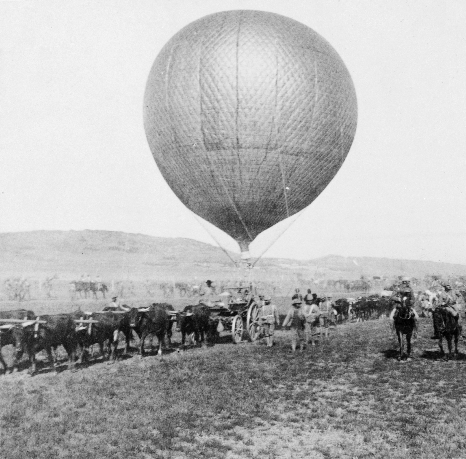
The true test of military ballooning in Africa came during the Second Boer War (1899–1902). Unlike earlier colonial expeditions, this was a modern, industrial-scale conflict fought across enormous distances. The British Army did not merely deploy balloons—it deployed an integrated system.
Initially, three balloon sections were sent to South Africa, equipped with tethered hydrogen balloons, gas wagons, and trained crews. As the war progressed, four additional sections were authorized, including a unit specifically tasked with aerial photography. For the first time in British military history, balloons were not just observation platforms but camera platforms.
From the air, observers documented Boer trench systems, road networks, and artillery emplacements. These early aerial photographs were often oblique, unevenly exposed, and difficult to interpret, yet they represented a fundamental shift: the battlefield was now being recorded, not merely described. Images were compared against maps, sketches, and ground intelligence to extract meaning from what initially appeared chaotic.
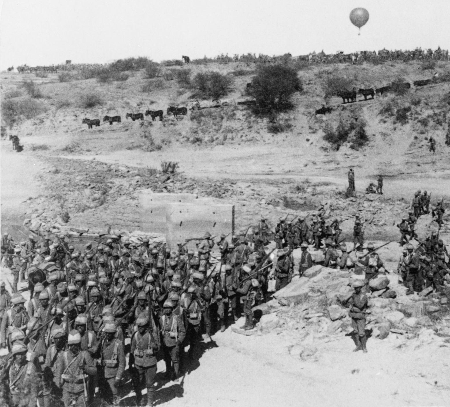
At engagements such as Magersfontein and Tugela Heights, balloon observers relayed enemy positions via signal flags and tethered telegraph lines, directing sustained bombardments that would have been impossible from ground-level observation alone. Photography reinforced these observations, providing commanders with a persistent visual reference that could be revisited and reinterpreted.
The psychological effect was significant. Boer fighters, many of whom relied on concealment and mobility, viewed the balloons with unease. One contemporary observer recalled that the balloons symbolized a form of scientific dominance that was deeply unsettling to those on the ground.
Limits of the Colonial Sky
Despite their successes, balloons remained vulnerable. Inflation could take hours. Wind, weather, and rough terrain frequently grounded operations. Hydrogen wagons, often drawn by oxen, struggled across veld and desert alike. Even when aloft, balloons were tempting targets for rifle fire and artillery.
Yet balloons often remained deployed for days at a time, moving with advancing columns and scanning territory that stretched far beyond the reach of patrols. In landscapes defined by distance rather than density, altitude offered clarity—if not certainty.
From Observation to Aerial Photography
From the Nile to Natal, ballooning in Africa was never about spectacle. It was about information. These campaigns demonstrated how elevation transformed warfare—first through observation, then through documentation. The Second Boer War, in particular, marked the moment when balloons crossed a threshold: from seeing the battlefield to recording it.
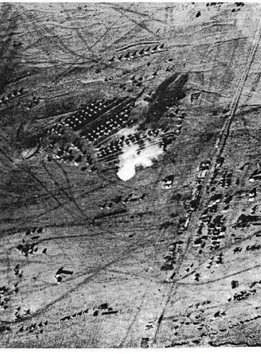
Early aerial photographs were imperfect and frequently illegible without context, but they introduced a new way of thinking about terrain and conflict. The land itself became a document, captured from above and subjected to analysis. In this sense, Africa’s colonial wars quietly shaped the early practice of aerial photography, foreshadowing the intelligence revolution of the twentieth century.
In the next installment of Balloons of War, ballooning rises once more—this time above the trenches of Europe. World War I sees observation balloons reach their apex, operating amid barbed wire, artillery, and an entirely new kind of industrial war, even as airplanes began to challenge their dominance.