
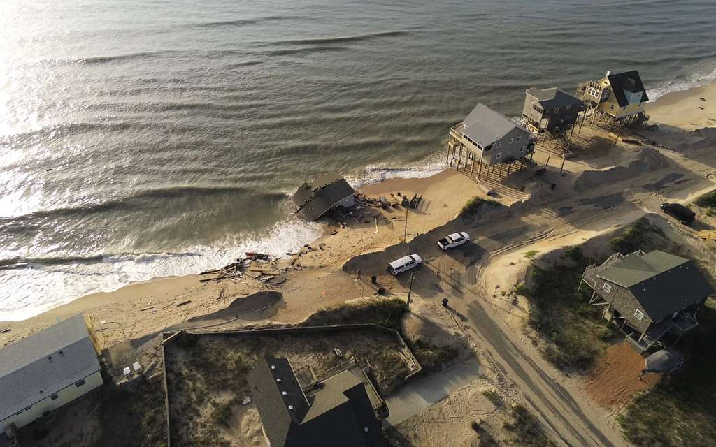
Since 2020, 32 houses have collapsed onto beaches along North Carolina’s Cape Hatteras National Seashore. Twelve were in Rodanthe, twenty in Buxton. Fifteen Buxton houses fell in just six weeks during 2025.
All were unoccupied when they collapsed. But each left behind a troubling question: What happens to private property when the ocean takes the land beneath it?
The danger hasn’t passed. In October 2026, following another round of coastal storms, the National Park Service warned that several oceanfront houses in Rodanthe remained structurally compromised and at risk of collapse. The threat extended beyond the properties themselves: exposed septic systems and debris carried along the shoreline posed hazards to public beaches.
Across the country, California was confronting its own coastal emergencies. Powerful waves damaged oceanfront homes in Southern California, while erosion and slope instability threatened a section of Pacific Coast Highway near Crystal Cove.
The threats look different on opposite coasts. Along the Outer Banks, houses stand on beaches that have narrowed or disappeared. On California’s coast, waves can undermine the cliffs supporting buildings and highways.
Both coasts face the same problem. The shoreline is moving. But do property lines move with it?
When the beach moves toward your house
In a 1983 aerial photograph of Rodanthe, North Carolina, a broad stretch of sand separates the Atlantic from the first row of oceanfront homes. By 2024, sections of that beach have narrowed dramatically. Houses once sheltered behind dunes now stand dangerously close to the surf.
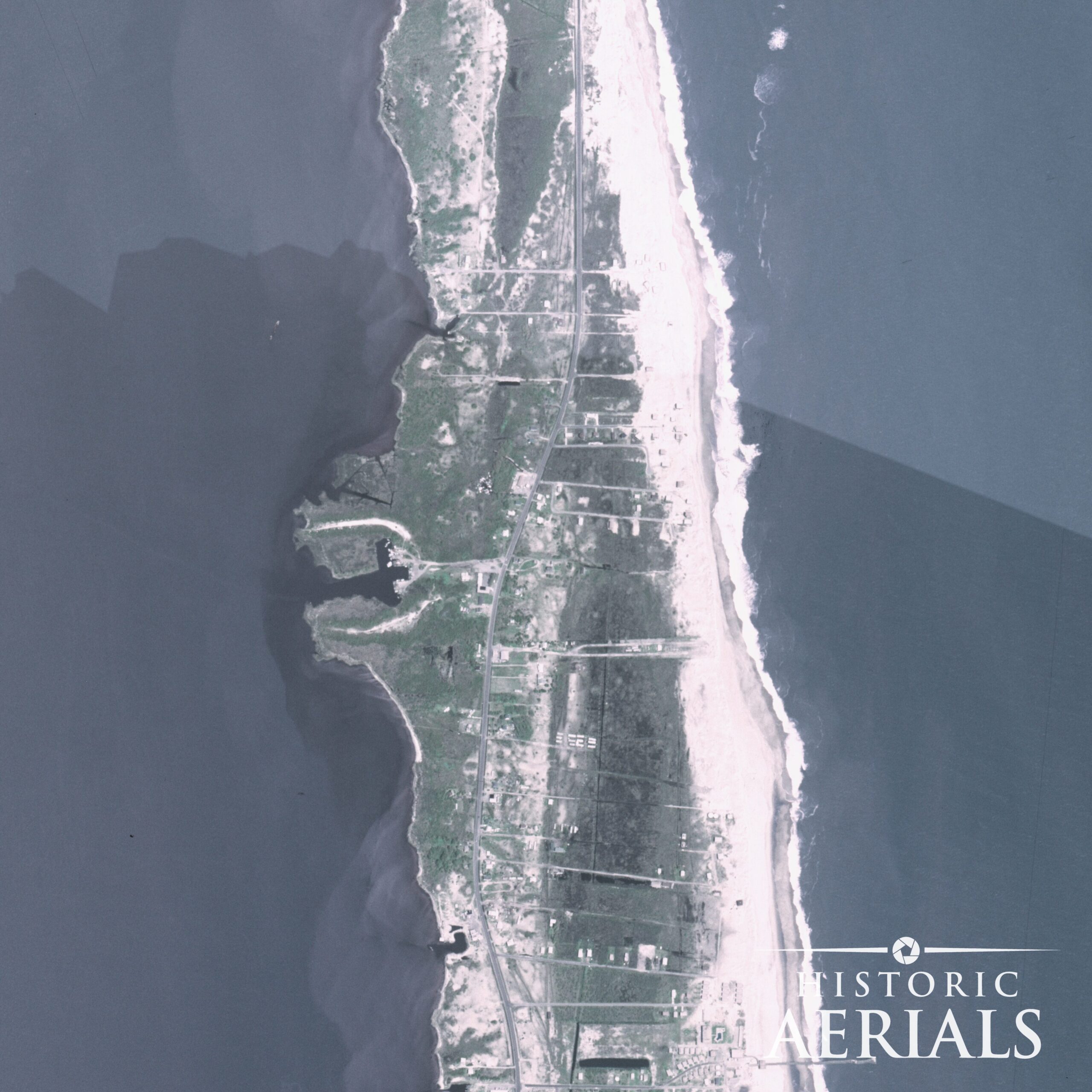
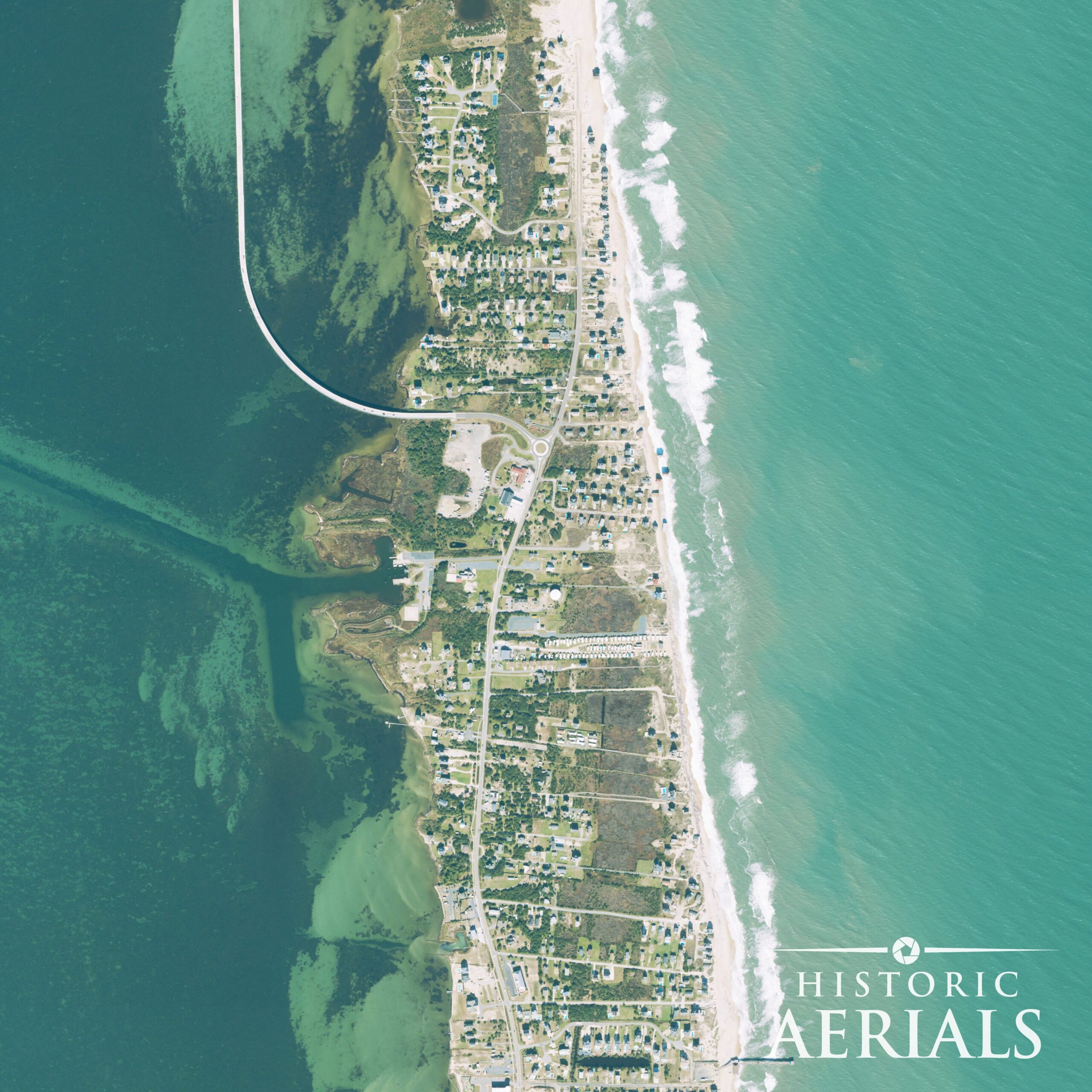
Even the highway had to retreat. In 2022, North Carolina opened the $155 million, 2.4-mile Rodanthe Bridge, carrying NC 12 over Pamlico Sound to bypass a stretch of highway repeatedly threatened by ocean overwash.
The aerial photographs reveal how the ocean has steadily reclaimed parts of the island. But the changing shoreline creates more than a physical threat. It raises complicated questions about ownership and public access.
In most coastal states, the boundary between private oceanfront property and state-owned shoreline follows the mean high water line. As gradual erosion pushes that line inland, the private property can shrink with it.
North Carolina adds another distinction. State law recognizes public rights to use both wet and dry portions of ocean beaches, even where the dry sand remains privately owned. The first line of stable natural vegetation is one indicator of the public beach’s landward extent.
That means a house built well behind the dunes can eventually find itself standing on a beach subject to public use rights, without the owner ever selling the property.
In 2023, the National Park Service purchased two threatened Rodanthe houses and paid $72,500 to remove them and restore the beach.
Can you stop the ocean with a wall?
For North Carolina property owners, the answer has generally been no.
Since 1985, the state has prohibited most new permanent oceanfront seawalls and similar hardened structures, a restriction written into state law in 2003.
The reasoning is that protecting one property with a wall can worsen erosion or beach narrowing nearby. Waves continue reaching the structure, and the beach in front of it may disappear.
That restriction is now being challenged. Senate Bill 1009, introduced in 2026, would repeal the prohibition and establish new regulations for erosion-control structures. As of the latest recorded action on June 17, the bill remained in a Senate appropriations committee.
The debate illustrates a difficult problem: protecting individual properties can conflict with preserving a beach that naturally shifts over time.
When a property line stops moving
Ordinarily, gradual coastal erosion and accretion can move waterfront boundaries. But sudden changes, engineered beaches, and public-access easements can produce different legal outcomes.
In Florida, a beach restoration project proposed adding approximately 75 feet of sand along 6.9 miles of shoreline near Destin and Walton County.
Under state law, a surveyed erosion control line would become the permanent boundary between private property and the publicly owned restored beach. Oceanfront owners challenged the arrangement, arguing that it deprived them of important waterfront rights.
In 2010, the U.S. Supreme Court upheld the state’s position. The new sand would belong to the state, while the owners retained their existing property boundaries.
Texas offers another example.
After Hurricane Rita struck Galveston Island in 2005, the vegetation line shifted inland, leaving a privately owned house on what the state considered a public beach.
In Severance v. Patterson (2012), the Texas Supreme Court ruled that an existing public beach easement does not automatically migrate onto previously unencumbered private land following a sudden, dramatic shoreline change.
The court distinguished gradual erosion from avulsion, a sudden change that can have different legal consequences.
These cases highlight an important distinction: Where the beach ends, who owns the land, and where the public has a right to walk aren’t always the same question.
On the West Coast, the ground disappears
In March 2016, demolition crews began tearing apart a vacant apartment building at 320 Esplanade Avenue in Pacifica, California. The building had stood near the edge of an eroding coastal bluff for years.
That winter, powerful El Niño storms had accelerated the erosion. A neighboring apartment building became uninhabitable in January and was demolished in 2017.
Unlike a sandy beach that can erode during a storm and rebuild afterward, a collapsed coastal bluff generally doesn’t recover. Once its ground falls into the ocean, it is effectively gone.
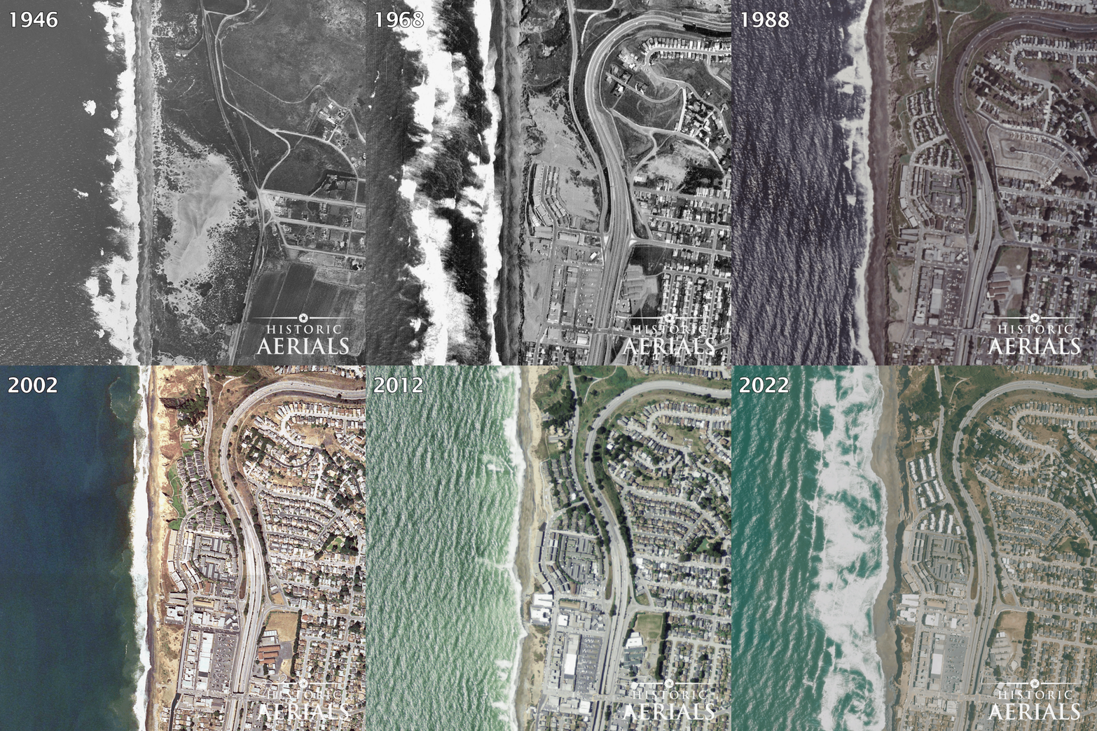
Historic aerial photographs reveal the transformation. In 1946, the bluff above the Pacific was mostly open land. By 1981, apartment buildings occupied the terrace. Several decades later, buildings along the bluff’s edge had disappeared.
The threat remains very much alive. In October 2026, renewed concern over coastal erosion and the approaching El Niño storm season prompted warnings along the San Mateo County coastline. Pacifica was undertaking emergency stabilization work on its damaged Municipal Pier, while county officials prepared for the possibility of unusually high water levels and powerful surf.
The historical aerial sequence shows what happened to the coastline over decades. Today’s warnings demonstrate why those changes matter to properties and infrastructure still standing near the edge.
The distinction from an eroding beach matters. On many bluff-top properties, surveyed lot lines are fixed independently of the cliff edge. As the bluff retreats, the legal boundaries may remain unchanged, even as the usable land disappears.
Farther north, another stretch of coastline demonstrates just how quickly that loss can happen.
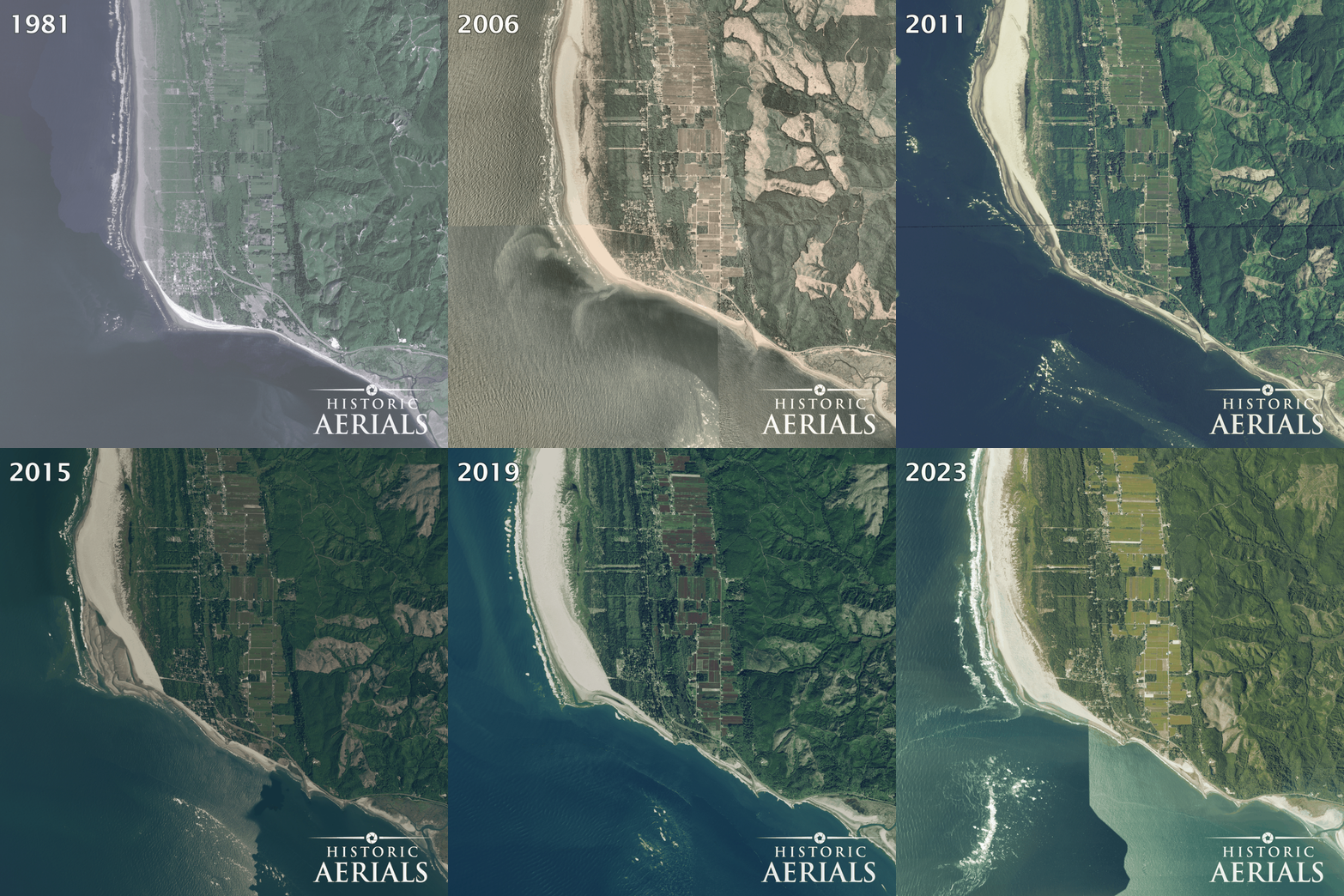
At North Cove, Washington, residents call the area Washaway Beach. According to the U.S. Geological Survey, the shoreline has retreated an average of approximately 100 feet annually since the early 1900s, among the fastest erosion rates on the West Coast.
A 1981 aerial photograph shows streets and houses near the water. By 2023, much of that developed land has disappeared beneath the ocean or been transformed into beach.
Nearby, portions of the shoreline have accumulated sand even as others eroded. The same coastal processes that destroy land in one location can build it somewhere else.
Recent research is bringing that changing landscape into sharper focus. In October 2026, scientists at UC San Diego’s Scripps Institution of Oceanography released findings from a statewide study comparing airborne lidar surveys conducted in 2016 and 2023. Some California coastal cliffs had retreated more than 70 feet per year during that period, although erosion rates varied considerably from one location to another.
Studies like this demonstrate the importance of understanding how coastlines change over time. While modern surveying technologies can measure the rate and extent of erosion, historical aerial photographs provide a longer view, revealing how shorelines, development, and infrastructure have changed over generations.
What historic aerials can tell a coastal buyer
A deed and survey establish important facts about ownership. But they cannot, by themselves, show how a coastline has changed over the decades.
Before purchasing waterfront property, investigate:
- Shoreline movement: How far has the beach or bluff edge retreated in historic aerial photographs?
- Erosion patterns: Has the retreat been gradual, or have storms caused major changes?
- Local restrictions: Can the property be protected with a seawall, or is shoreline armoring prohibited?
- Legal boundaries: Does the survey identify a moving water boundary, a fixed lot line, or a public-access easement?
- Future exposure: How do local erosion-rate maps, coastal hazard assessments, and recent lidar measurements compare with the changes visible in historical imagery?
At Rodanthe, the earliest photographs show houses standing well behind the beach. At Pacifica, they show buildings occupying ground that would eventually crumble into the Pacific.
When those buildings first appeared in the aerial record, many stood well back from a shoreline that has since advanced toward, or beyond, their foundations.
A deed may tell you what you own. Historic aerial photographs can show you how much of it the ocean has already taken, and what may be next.