In a World War I–era portrait, Edgar Gardner Tobin looks every bit the confident aviator: crisp attire, steady gaze, and the bearing of someone used to seeing the world from above. That same poise carried into his next act, when he turned peacetime flying into a new kind of business—systematic aerial photography of the modern landscape.

The story of commercial aerial photography in the United States is incomplete without Tobin. Born in San Antonio, Texas, he was a decorated World War I fighter pilot before helping to pioneer the commercial aerial photographic survey industry. The Edgar Tobin aerial surveys of the 1930s form a key record of that work.
From Battlefields to Oilfields: Edgar Tobin’s New Mission
After the war, Tobin returned to Texas and initially worked as an auto dealer, but his interest in aviation never faded. By 1928, he had established Edgar Tobin Aerial Surveys in San Antonio. In less than a decade, the firm grew into one of the largest aerial mapping companies in the world, providing photographs and maps to engineers, city planners, and—most importantly for our story—oil companies.
The skills Tobin honed in the cockpit would soon carry him back into military service. During World War II, he served as a special civilian aide to General Henry “Hap” Arnold of the United States Army Air Forces. Tobin and his company were heavily involved in mapping invasion routes and strategic targets, and they produced aerial coverage of the entire United States for the federal government. Their photographs and maps gave planners the kind of detailed, up‑to‑date geographic intelligence the modern air war demanded.
Before the world went back to war, however, Tobin and his crews spent the 1930s documenting something very different: the rapidly expanding oilfields of Texas, at the exact moment the petroleum industry was transforming forests, bayous, and small towns into a new industrial landscape.
Mapping the Oil Patch from the Air
By the early 1930s, oil companies such as Humble Oil and Refining Company (which later became part of Exxon) needed more than ground surveys and sketch maps. They were managing vast lease blocks, planning new wells, laying out pipeline routes, and building refineries and tank farms at a pace that was hard to track from the ground alone.
Tobin’s aerial surveys provided what the industry lacked: a synoptic, bird’s‑eye view of the oil patch. His crews photographed extensive tracts of land in Texas, capturing oil and gas wells, towns and cities, railroad lines, canals, tank fields, and early road networks in a single frame. These images helped companies identify promising drilling sites, plan pipelines that avoided wetlands and obstacles, monitor encroaching development, and document exactly how their leases were being used.
Remarkably, Tobin’s photographs from the 1930s represent the bulk of the earliest aerial coverage we have for many of these Texas oilfields. On HistoricAerials.com, they preserve a snapshot of the region before modern freeways, suburban subdivisions, and sprawling industrial corridors rewrote the map.
If you open the HistoricAerials viewer and slide between the 1930 imagery and more recent decades, you can literally watch derrick lines vanish, refineries expand, and residential streets spread across ground that Tobin’s crews once photographed as open fields or dense clusters of wells.
The Humble Oil Field at Moonshine Hill

Located in Humble, Texas—which happens to be this writer’s hometown—the Humble oilfield was one of the state’s earliest and most important oil discoveries. The field was discovered in 1904 and rapidly developed into a leading producer, helping to cement Texas’s place at the center of the American oil business. By 1930, Humble was a mature, intensely worked field, with Moonshine Hill as one of its most active sections.
In the 1930 imagery of Moonshine Hill, as the view moves across the field, rows of derricks trace the contours of the terrain, clustered tightly along ridges and access paths. Narrow roads and tracks thread through the maze of structures, with very little separation between industrial and residential areas by today’s standards. Storage tanks and small buildings appear as pale geometric shapes amid the darker patches of cleared land and remaining vegetation.
A ground‑level photograph from the same area reinforces the impression.
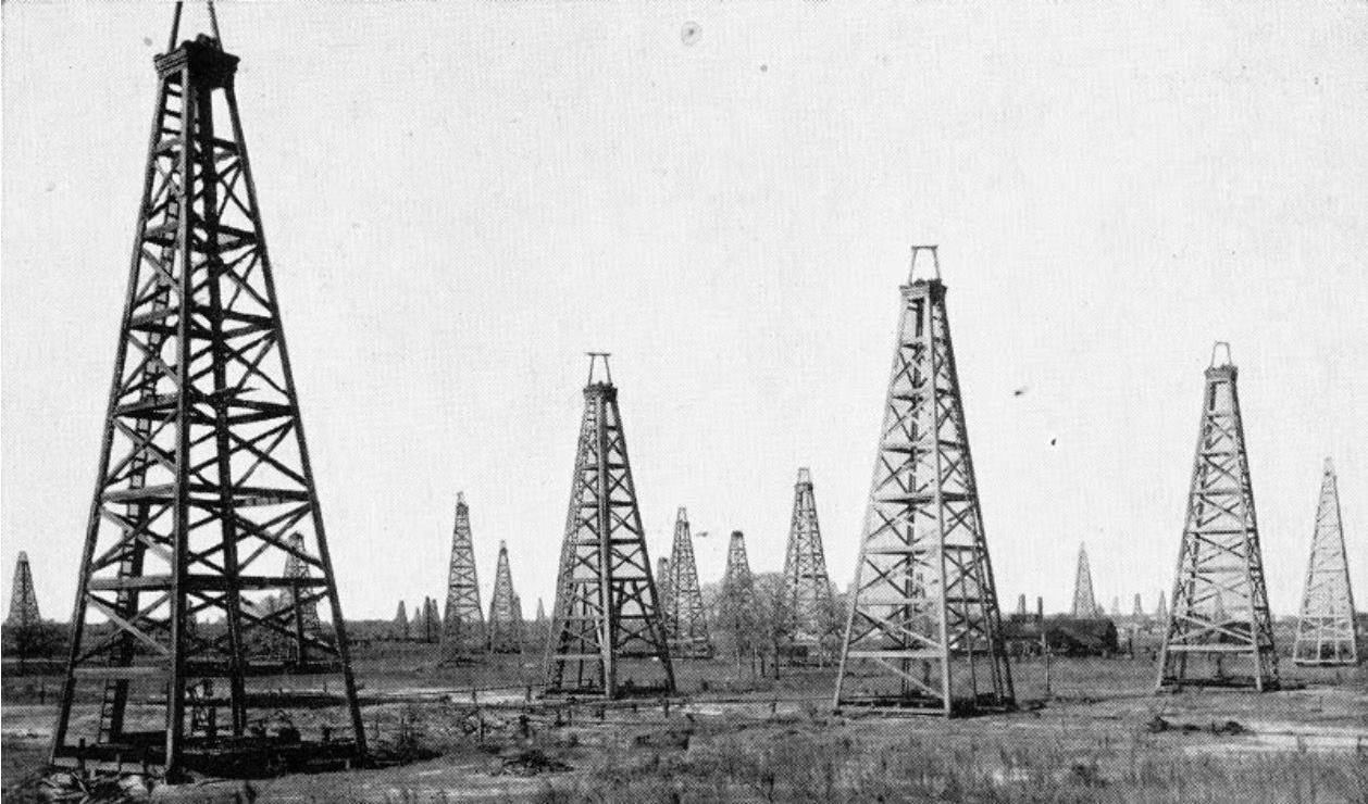
Seen together, the aerial and ground views show Humble at the height of its boom: a landscape dominated by vertical lines of steel, with the town, farms, and forests pushed to the margins. In the HistoricAerials viewer, sliding forward through later decades reveals how quickly those lines disappeared, replaced first by more orderly industrial layouts and, eventually, by the familiar patterns of suburban streets and shopping centers.
Goose Creek: Pioneering Offshore Drilling in Tabbs Bay

The Goose Creek oilfield, located in Baytown, Texas near the shores of Galveston Bay, was another pioneering site of the early Texas oil boom. Discovered in 1903, Goose Creek gained fame not only for its production but for its role in the development of offshore drilling. By 1917, it was yielding substantial quantities of oil and had become a laboratory for new ways of reaching reservoirs that extended beneath the shallow waters of Tabbs Bay.
Goose Creek was the site of the first offshore drilling platforms in Texas—and only the second such effort in the United States. Operators built wooden structures out into the bay and mounted derricks on top, effectively extending the oilfield into the water.
In Tobin’s 1930 imagery of Goose Creek, the platforms appear as delicate lines projecting into Tabbs Bay, each dotted with neatly spaced derricks. On the shoreline, tank farms, roads, and rail spurs knit the offshore rigs into a larger industrial system. The pattern makes clear just how experimental early offshore work was—these were platforms exposed to storms, waves, and shifting sediments, with far fewer protections than modern offshore installations.
Exploring Tobin’s Legacy on HistoricAerials
For the oil industry of the 1930s, Tobin’s aerial surveys were a technological leap. They reduced guesswork in exploration, helped companies evaluate leases more efficiently, and gave engineers a way to visualize the full layout of fields, pipelines, and support facilities at once. That same synoptic view is what makes the Edgar Tobin Aerial Surveys of Texas, 1930s collection so valuable today.
On HistoricAerials.com, Tobin’s work is no longer confined to paper prints or specialized archives. In the online viewer, you can search for places like Humble, Baytown, or Beaumont, select the 1930s imagery, and see the oilfields much as Tobin’s crews recorded them from above. Using the Compare slider to fade between those 1930 views and modern aerials or topo maps, it becomes easier to trace how derrick lines vanished, refineries expanded, and suburbs and highways spread into what was once an almost continuous industrial landscape.
The forthcoming documentary Bird’s Eye View will follow Edgar Tobin’s story in more detail—from World War I pilot to oilfield surveyor to World War II mapping expert.