In a 1975 Arizona Republic report on the Moreland Street corridor in Phoenix, a reporter observed that the neighborhood had dropped from roughly 9,000 residents to fewer than 1,500. Bulldozers had been working that stretch for years. But the freeway itself wouldn’t open for another fifteen.
That 15-year gap between the removal of a community and the paving of a road is what makes the Phoenix case worth studying today. The saga of the Papago Freeway offers a stark, enduring lesson for modern urban development: cities cannot simply throw up freeways wherever it is mathematically efficient, and they cannot leave it to engineers alone to dictate solutions for the communities they serve.
When infrastructure is imposed rather than negotiated, the result is rarely progress. Instead, what you get is gridlock. And nowhere is that gridlock more visible than from the air.
The myth of the blank slate
Operating on a mandate that prioritized cars over community, the Arizona Highway Department began acquiring properties around 1960. The engineering logic was straightforward: this was the most direct, convenient path to connect the transcontinental gap of Interstate 10.
Planners often treated urban maps as blank slates, but the archival record proves otherwise. In aerial imagery from 1958, the Moreland corridor is clearly visible as a dense, functioning urban grid.

These were not vacant parcels awaiting a grand purpose. They were homes. The planners expected construction to follow quickly after acquisition.
It did not.
The “Corridor of Uncertainty”
In most highway construction, clearance and building happen in close succession. Here, they were separated by more than a decade, creating a condition known as “condemnation blight.” Properties in the acquisition zone lost value. Not because the freeway had arrived, but because it might. Owners stopped maintaining structures they expected to lose. Renters moved on.
This holding pattern created a distinct visual signature. The 1973 aerial image does not show the clean scar of a highway under construction. Instead, it reveals a “corridor of uncertainty,” a two-block-wide band running east-west through the center of the city where the built density drops sharply, interrupted by vacant parcels in various stages of clearing. It reads as a physical wound, an area held in agonizing suspension.
Future Phoenix mayor Terry Goddard, who moved into the Roosevelt neighborhood during this period, famously described the corridor as looking “like a prairie with streets.”
The limits of engineering and the power of leverage
The cause of this limbo was political, and it proved that the leverage of local organization should never be underestimated.
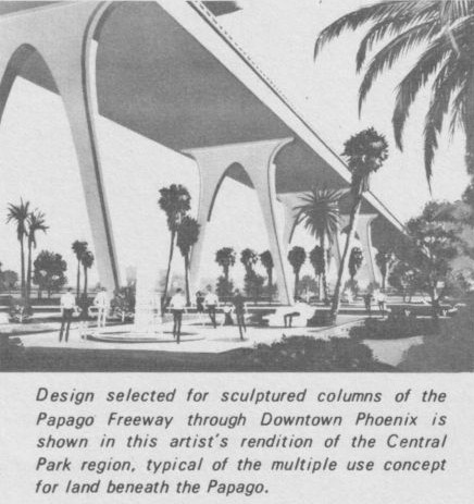
Engineers had proposed a bold design for the freeway: a 100-foot-elevated structure featuring dramatic, soaring spiral interchanges dubbed “Helicoils.” From a strict traffic-flow perspective, the helicoils were a structural marvel. From an urban planning perspective, they were a disaster that would have broadcasted noise for miles and cast permanent, blighting shadows over the city center.
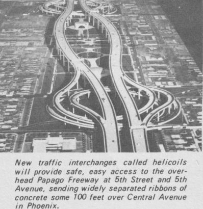
The planners severely underestimated the civic response. Led by Eugene Pulliam, the influential publisher of The Arizona Republic, a fierce opposition campaign branded the design the “100-foot-high mistake.” The public organized, pushing back against the assumption that they had to accept a divisive concrete behemoth simply because the state deemed it efficient.
In May 1973, Phoenix voters went to the polls and rejected the elevated design by nearly three to one. The vote stopped the engineers cold.
However, it could not stop the clearance that had already happened. The state held hundreds of properties along the alignment, many already demolished. For the residents who remained, the vote extended their limbo. The standoff proved that when a city ignores community input, it creates a physical, decaying void in the heart of its own geography.
The necessity of creative compromise
Phoenix eventually resolved its freeway impasse, but only by dispensing with antiquated, “path of least resistance” methods of automobile infrastructure.
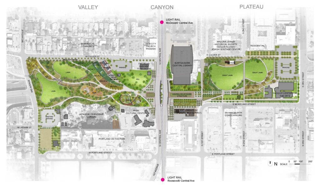
With the cheap, elevated option legally blocked, the state was forced to embrace what had previously been dismissed as financially unviable. Engineers were tasked with a highly creative, context-sensitive compromise: depressing the freeway below grade in a cut-and-cover trench and building a massive, 29-acre deck park above it to physically reconnect the severed neighborhoods.
The engineering challenges required to fix the social problem were staggering:
- Structural Stabilization: Slurry wall construction was required to stabilize the sandy alluvial soil adjacent to historic structures during a 30-foot excavation.
- Flood Mitigation: A parallel network of massive drainage tunnels was built to handle stormwater that would otherwise turn the trench into a river during monsoon season.
- Archaeological Salvage: Excavations revealed La Ciudad, a Hohokam settlement from roughly A.D. 750, triggering one of the largest archaeological salvage projects in American transportation history.
- Massive Costs: The tunnel section alone, composed of 19 side-by-side concrete bridges, cost more than $55 million in 1980s dollars.
Construction finally began in 1983, and the freeway opened in 1990.

The legacy of the final link
Margaret T. Hance Park, which sits above the tunnel today, is the visible trace of that hard-fought compromise. It stands as physical proof that equitable community service and massive infrastructure are not mutually exclusive, but achieving both requires tearing up the old playbook.
In Phoenix, the freeway’s story didn’t start when the concrete was poured. It started when the corridor began to empty. The aerial archive is where you can see that earlier, quieter chapter, block by block. It demonstrates that efficiency cannot supersede equity, and that treating community input as an essential pillar of design is the only way to build infrastructure that truly serves the city it runs through.