As America marks its 250th anniversary, we put together an animation tracing how the United States took shape, from the first map of the new federal government in 1789 through the admission of Hawaii in 1959. Not the short version from a textbook, but the whole strange, winding journey, told through the map itself.
The map series animation above shows the United States grow from a thin strip of colonies along the Atlantic to the country we know today, stretching from one ocean to the other and beyond. Watch it once, start to finish. Then let’s talk about what you just saw, because almost every frame hides a story most Americans have never heard.
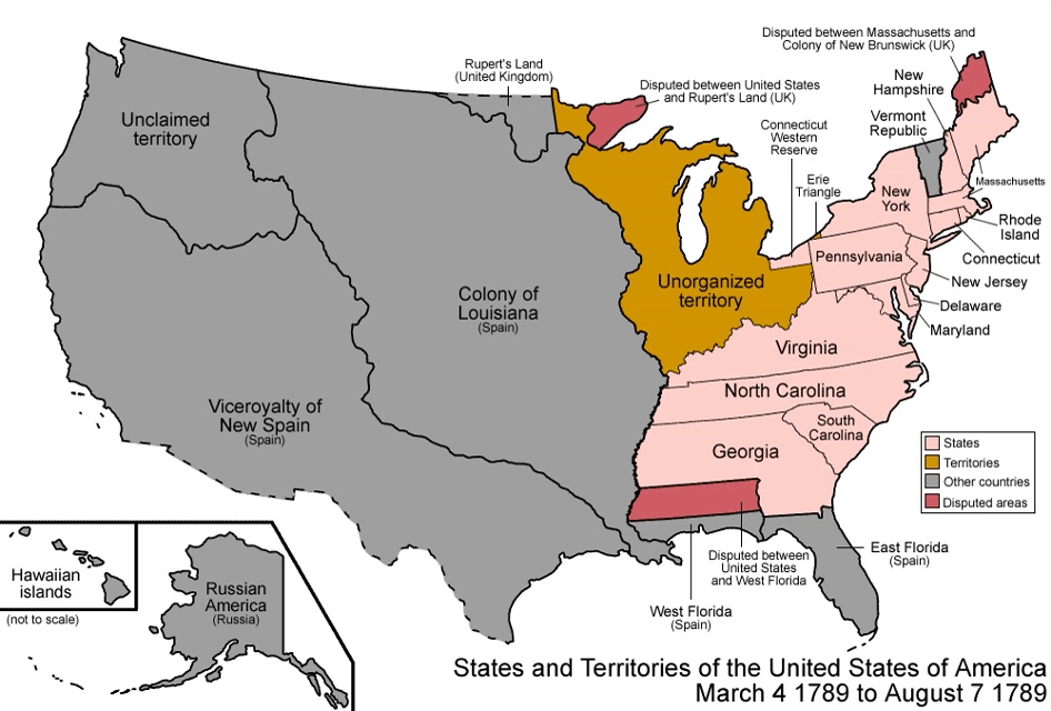
What surprised us most is how messy the process was
Here’s the thing most people get wrong. We tend to picture American expansion as a simple westward march, with new states added one by one as settlers moved across an empty map.
That’s not how it happened.
The United States didn’t expand in neat, orderly steps. Borders shifted through treaties, purchases, disputes, compromises, and statehood movements. A young America once claimed land that is now part of Canada. Texas once extended far beyond its current borders. The Louisiana Purchase nearly doubled the nation’s size overnight, and when the state of Louisiana was later carved from it, the remaining territory had to be renamed “Missouri Territory” just to avoid confusion.
At Historic Aerials, we spend our days studying how landscapes change through time. This animation tells a similar story on a much larger scale: the evolution of an entire country.
Read all the American history you want, and there are still moments in this map series that will surprise you.
A country built from many others
Long before it was the United States, this land was claimed, fought over, and lived on by people from all over the world. You can still see their fingerprints everywhere today.
Walk down Wall Street in New York, and you’re following the exact line of a wooden wall the Dutch built in 1653. Sweat through a summer in Houston, and you’re standing on ground that flew the flags of Spain, France, an independent Mexico, and the Republic of Texas before it ever belonged to America. Sip wine on the Sonoma Coast in California, and you’re just down the road from Fort Ross, once the southernmost outpost of the Russian Empire in North America.
Those countries left their words behind, too. The French gave us Detroit, Des Moines, and Baton Rouge. The Spanish gave us San Francisco, Santa Fe, and St. Augustine. The English gave us Birmingham, New York, and Charleston. And from the many Native American languages come names we say every day: Tallahassee, Cincinnati, Chicago, Omaha. The map of America is really a map of everyone who was here first.
Every map tells a story
Each of these 47 maps captures a single moment in the territorial evolution of the United States. Behind every shifting border is a story about how the map changed, and why.
Some are tales of treaties and land purchases. Some are about disputes and broken promises. Others are downright strange: rival governments claiming the same desert, a country that existed for barely two months, and a county boundary so contentious it ended up before the Supreme Court.
We’ll take you through this story era by era, stopping at the moments where the map changes in unexpected ways and the stories become impossible to ignore. Watch the animation as many times as you like, and then come along as we tell the stories hiding inside it.