
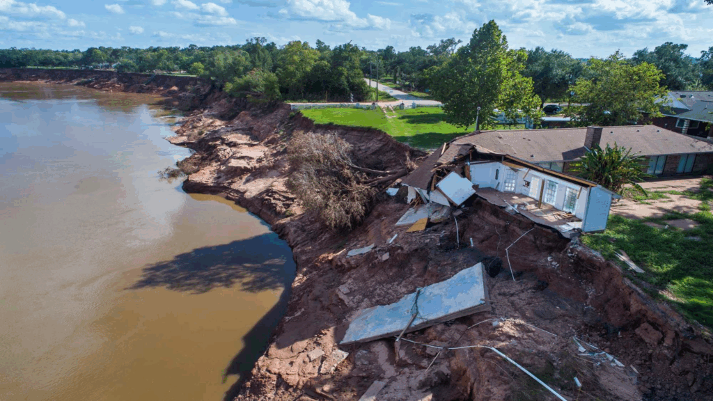
At Simonton, Texas, two bends of the Brazos River have been creeping toward each other for nearly a century. Between them sits a neighborhood. And as the river eats away at its banks, an uncomfortable question comes into focus: What happens to property lines when the land itself moves?
A 1930 aerial photograph shows a broad neck of woods and farmland between the bends, with no houses in sight. By 1969, streets and a few homes had appeared. More followed by 1993. Across images taken through 2022, the northern bend advances southward, steadily narrowing the land between the loops.
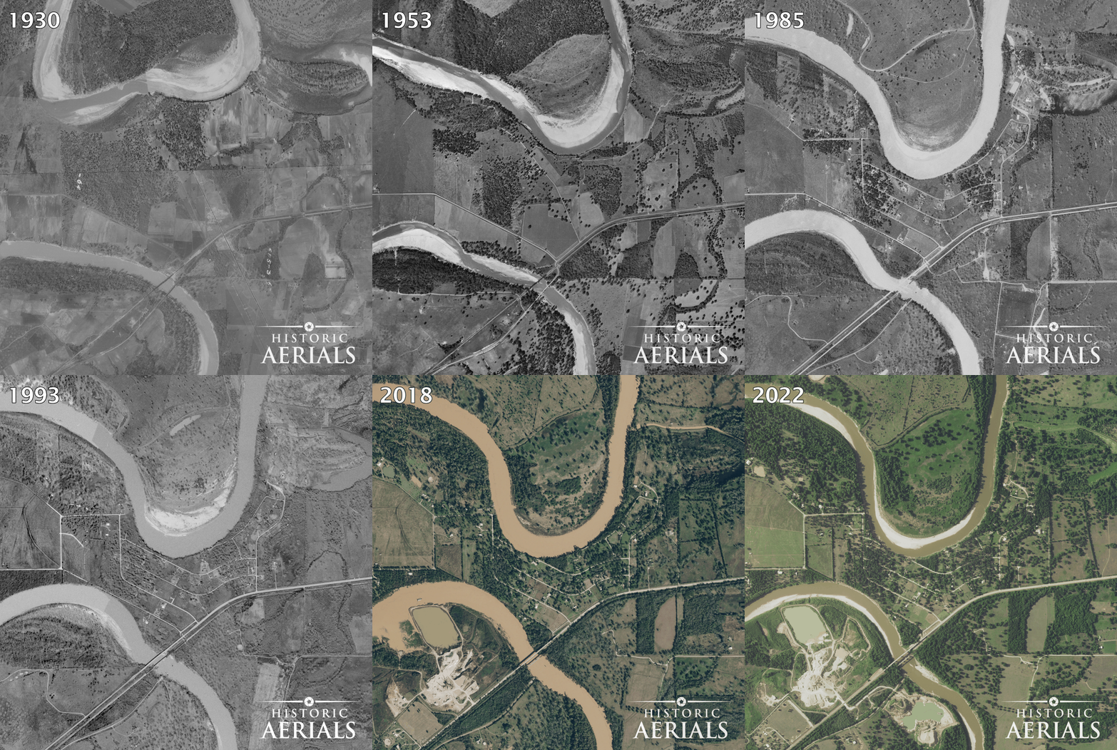
This is what meandering rivers do. But the consequences aren’t purely geographical. Depending on how a river changes course, the legal boundaries of the properties along it may move, or stay exactly where they were.
A river can take land, and add it elsewhere
Water flows faster along the outside of a bend, wearing away the bank. On the inside, slower water often deposits sediment and builds new ground. The river doesn’t simply shift across the landscape; it redistributes land along the way.
Property law has distinct names for these changes:
Erosion is the gradual wearing away of land. An owner whose riverbank retreats may lose property.
Accretion is the gradual buildup of land through deposited sediment. An adjoining owner may gain property as the bank extends outward.
Reliction is different: land becomes exposed when water gradually and permanently recedes, rather than when sediment builds a new bank.
Where a property boundary legally follows the water, gradual erosion, accretion, or reliction can shift it. The precise outcome depends on state law and how the boundary is defined.
At Simonton, the visible threat to homes near the outside of a bend is erosion. Owners along depositional banks elsewhere on the river may experience the opposite: land gained through accretion. These aren’t hypothetical processes. Historic aerial photographs let us watch the shoreline change over decades.
What if the two bends meet?
Engineers call the possible breakthrough at Simonton a neck cutoff. An August 2022 presentation posted by the City of Simonton modeled a scenario in which the Brazos breaks through the narrow strip, shortening its course by roughly six miles. Under a modeled 100-year flood, upstream water velocities could increase by nearly 19 percent.
A cutoff isn’t considered imminent. In 2024, the Texas General Land Office committed about $25.8 million to a project intended to stabilize the riverbanks and reduce the risk. Yet gradual erosion is already costly: one homeowner reported losing about 10 feet of yard in five years.
If the bends ever connected suddenly during a flood, the river’s new course could raise a very different ownership question. That brings us to another legal term: avulsion.
When the water moves but the boundary doesn’t
Avulsion is a sudden, identifiable change in a waterway’s course, often during a flood. Unlike gradual erosion or accretion, it generally does not move an existing property or political boundary.
Two unusual American towns show why that matters.
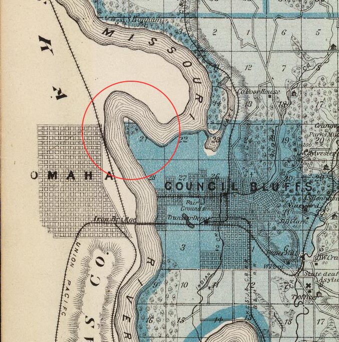
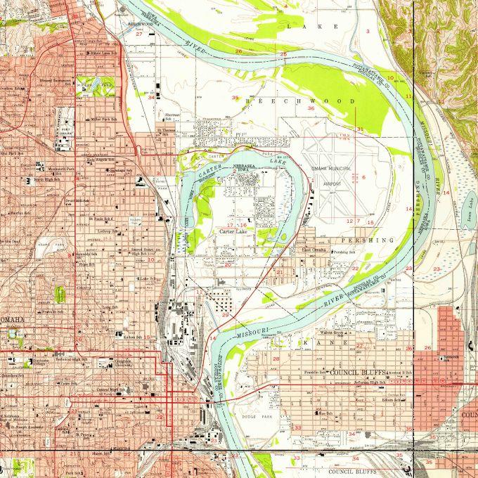
In 1877, floodwaters pushed the Missouri River across the neck of a bend near Omaha. The river’s shortcut left Carter Lake on the Nebraska side of the new channel. Yet in 1892, the U.S. Supreme Court ruled that the Iowa–Nebraska boundary had stayed in the former channel. Carter Lake remains part of Iowa.
In 1881, the Mississippi River made a sudden change near Kaskaskia, Illinois, leaving the settlement on the Missouri side of the river. Kaskaskia is still Illinois territory. To reach it by road today, you travel through Missouri.
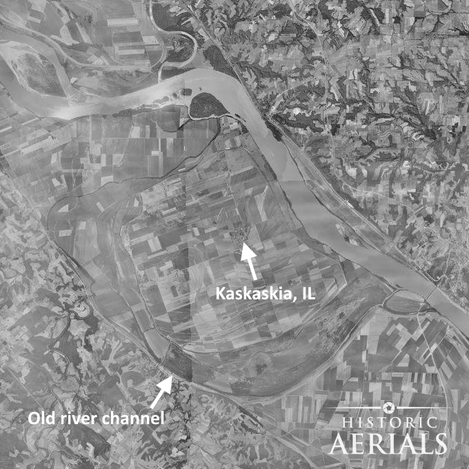
Carter Lake and Kaskaskia illustrate avulsion: a sudden channel change that leaves a legal boundary behind. Simonton illustrates a different process happening now—gradual erosion and accretion. Only if a future breakthrough occurred suddenly might avulsion enter the picture. The distinction is about how the water moved, not merely where it ended up.
Not every waterfront follows the same rules
Even without a dramatic river cutoff, owning property beside water comes with complications.
Along most oceanfronts, the mean high water line helps determine the boundary between private property and public land, although state rules differ. On the Great Lakes, the ordinary high water mark is often important. Inland lakes may follow other boundaries, depending on navigability, ownership of the lakebed, and state law.
Reservoirs add another wrinkle: the government may own land between a private lot and the water, even when the lot is marketed as waterfront.
Rivers have their own distinctions. States generally own the beds of navigable rivers. In Texas, certain streams at least 30 feet wide are considered navigable by statute, and the gradient boundary is used to establish the public–private divide. Smaller streams may have boundaries extending to the channel’s center.
And access isn’t ownership. A shared dock, boat ramp, or deeded easement may give someone a way to reach the water without conveying the shoreline.
Before you buy, look backward
A deed and survey help establish where a property’s legal boundaries lie. Dated aerial photographs answer a different question: What has the land been doing?
For riverfront property, they can reveal whether a lot lies on an eroding outer bend or a growing inner one; how far a bank has migrated; and whether old channels, oxbows, or curved floodplain scars reveal earlier river courses. Those observations can help identify what needs closer examination in the deed, survey, and applicable law.
At Simonton, the earliest photographs show the land before the streets and houses arrived. They also show that the river’s path was never fixed. No prediction was necessary to see the pattern—only a look at where the Brazos had already been.
The river may never cut through at Simonton. But its history offers a lesson for waterfront owners everywhere: A property line may look permanent on a map. The water beside it has other plans.