
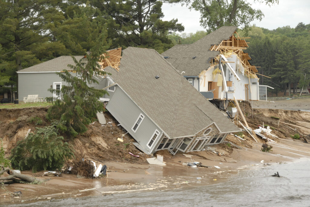
In January 2013, Lake Michigan reached its lowest recorded monthly water level. Seven years later, it was breaking monthly high-water records. Along parts of its shoreline, beaches disappeared beneath rising water, waves attacked bluffs, and homes stood dangerously close to the edge.
For waterfront property owners, the change was dramatic. But the bigger question is what those swings reveal about land that can appear perfectly safe for years before the water returns.
And sometimes, even a property advertised as “lakefront” doesn’t actually reach the lake.
A shoreline transformed
In a 1955 aerial photograph near St. Joseph, Michigan, a broad, pale beach stretches along Lake Michigan. Behind it, a wooded bluff rises toward orchards and open fields.
By 2022, the scene has changed. Houses occupy much of the former farmland, the visible beach is considerably narrower, and a bare bluff face extends along much of the shore. At the southern end, a curved shore-protection structure separates the developed land from the lake.
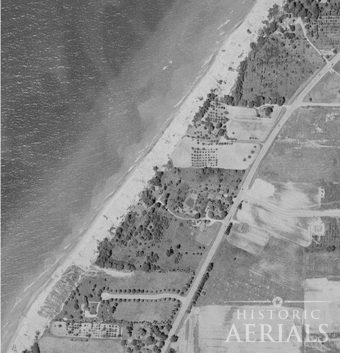
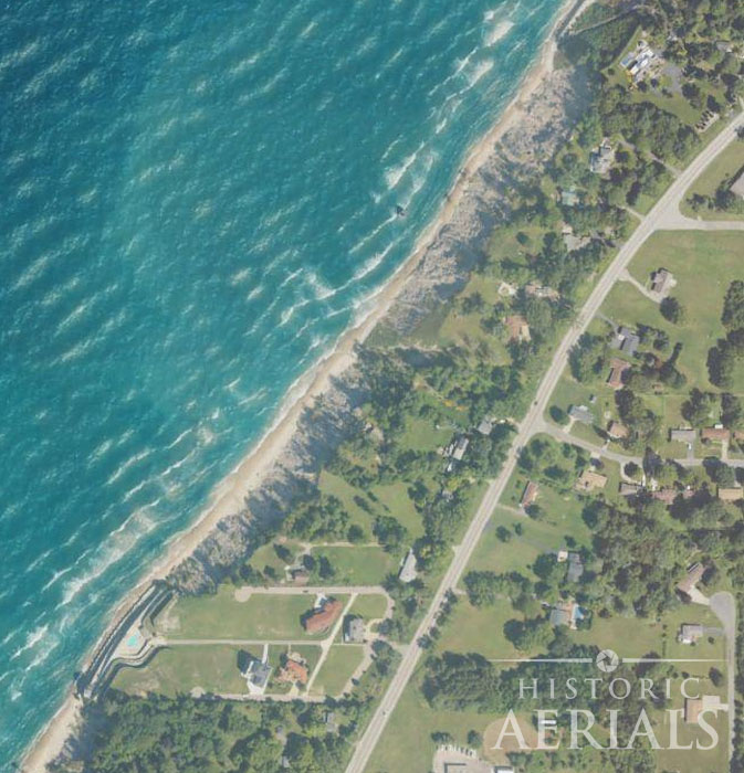
Some of the difference in beach width may reflect the lake’s water level when each photograph was taken. But bluff erosion is another matter.
When high water allows waves to strike the base of a bluff, they can remove the material supporting the slope above. Eventually, the ground gives way.
On New Year’s Eve 2019, a century-old cottage near Montague, Michigan, fell from an eroding bluff into Lake Michigan.
As water levels fall, exposed beaches may widen again. A collapsed bluff, however, doesn’t simply grow back.
Where does lakefront property end?
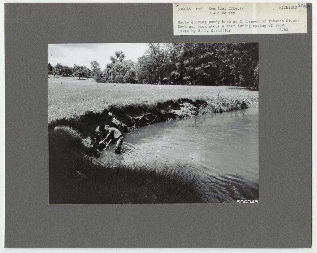
Unlike ocean tides, water levels in the Great Lakes fluctuate primarily with precipitation, evaporation, runoff, and other environmental conditions. Those changes can play out over seasons, years, and decades.
The legal boundaries are equally important.
In Michigan, the ordinary high water mark helps define the limits of public rights along the Great Lakes. In Glass v. Goeckel (2005), the Michigan Supreme Court ruled that the public has the right to walk along the shore below the natural ordinary high water mark, including where adjoining land is privately owned.
The mark reflects where water has left a recognizable trace through erosion, changes in vegetation, or other physical evidence. Michigan also uses specified high-water elevations for shoreline regulation.
For owners building near an eroding bluff, another boundary matters: the construction setback.
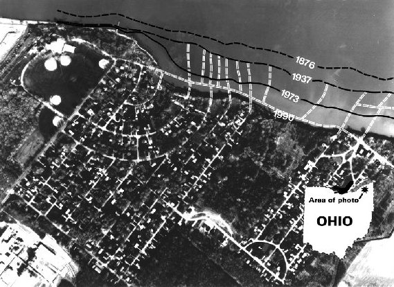
Michigan designates High Risk Erosion Areas where shorelines have retreated an average of at least one foot per year over a minimum of 15 years.
New construction in those areas must generally be set back according to projected shoreline recession: 30 years for qualifying movable structures and 60 years for structures that aren’t readily movable.
Those projections aren’t guesswork. The state uses historic and modern aerial photographs, shoreline measurements, and field observations to calculate erosion rates.
The same records can help a prospective buyer understand why a particular property has building restrictions, or why a house standing safely today might not be safe decades from now.
When “lakefront” doesn’t mean waterfront ownership
Natural lakes aren’t the only places where appearances can mislead buyers.
At Lavon Lake, a U.S. Army Corps of Engineers reservoir northeast of Dallas, the federal government owns the lakebed and a strip of land extending beyond the normal water’s edge.
The lake’s normal pool elevation is 492 feet above sea level, but the federal property boundary lies farther inland. Private lots adjoining that boundary may have lake views or pedestrian access without owning the shoreline.
And the restrictions don’t necessarily end at the property line.
On certain privately owned parcels, the government holds flowage easements, giving it the right to flood land up to an elevation of 509 feet. Those easements restrict construction and other activities.
A buyer might discover that a lot advertised as lakefront neither touches the water nor allows a house to be built on part of the property.
The lesson is simple: Before buying waterfront property, find out exactly what you’re buying, and what rights someone else already holds.
Six things to check before buying waterfront property
A deed describes ownership. A survey locates boundaries. Historic aerial photographs reveal how the landscape has changed around them.
Together, they can help answer questions that a waterfront listing rarely addresses.
1. Identify the legal boundary.
Does the property extend to the water, an ordinary high water mark, a surveyed boundary, or the center of a river channel? On a reservoir, does government-owned land separate the lot from the lake? Find out before assuming the shoreline belongs to you.
2. Obtain a current survey and review the deed.
Have a qualified surveyor identify the legal boundaries, recorded easements, nearby structures, and any relevant shoreline or bluff features. Ask when those features were measured. A boundary shown on an old survey may not reflect the landscape today.
3. Examine decades of historic aerial photographs.
Compare the shoreline across as many dated images as possible. Measure changes relative to stable landmarks, such as roads and longstanding buildings. Look for retreating banks, exposed bluffs, abandoned channels, and new sediment deposits.
Remember that water levels vary. A wider beach in one image doesn’t necessarily mean land has accumulated. Compare lake levels and image dates before drawing conclusions.
4. Check erosion maps and building restrictions.
State and local agencies may publish shoreline recession rates, erosion hazard areas, and setback requirements. Determine whether the property has restrictions on building, shoreline armoring, docks, or filling. Compare official estimates with the history visible in aerial imagery.
5. Investigate insurance before making an offer.
Standard homeowners insurance typically excludes damage caused by gradual earth movement or erosion. Federal flood insurance may cover certain building damage associated with sudden, qualifying flood-related erosion, but not ordinary gradual shoreline loss or the land itself.
Get quotes and confirm coverage limitations before committing to a purchase.
6. Bring in the appropriate experts.
A land surveyor can establish boundaries. A real estate attorney can evaluate deeds, easements, and waterfront rights. On eroding bluffs, a geotechnical engineer can assess slope stability and potential failure.
Give them the historical aerial record. Knowing where the shoreline stood decades ago can be as valuable as knowing where it stands today.
The view tells only part of the story
Waterfront property can remain stable for generations. Other shorelines change enough within a few decades to threaten homes, roads, or entire neighborhoods.
Lake Michigan’s dramatic water-level swings illustrate why a single photograph or survey cannot tell the complete story. At reservoirs, the concern may be less about erosion than about ownership boundaries and restrictions that aren’t visible from the backyard.
The common thread throughout this series is that waterfront ownership involves more than the land and water visible today.
Before buying, look backward.
The best view of a property’s future may begin with a photograph of its past.